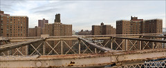
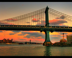
New York Songlines: Cherry Street

Pearl | Wagner | Catherine | Market | Pike | Rutgers | Jefferson | Clinton | Montgomery | Gouverneur | Jackson | FDR

Named for the cherry orchard of Goovert Loockermans, a wealthy Dutch merchant who produced the best cherries in town. His heirs sold the land to Richard Sackett in 1672, who opened a beer garden and bowling green here known as Sackett's Orchard. For a time the street was known as Sackett Street.


S <===     PEARL ST/FRANKFORT ST     ===> N


S <===     DOVER ST/PEARL ST     ===> N

The western boundary of the Two Bridges neighborhood.

Brooklyn Bridge

Brooklyn Bridge by sono salvo, on Flickr

Construction on the bridge began in 1870; when completed in 1883, it was half again as long as any other suspension bridge in the world. At least 16 people died in its construction, including its architect, John Augustus Roebling, who contracted tetanus after his foot was crushed by a ferry. His son Washington Roebling, who inherited the project, was stricken by compression sickness while working in cassions, leaving Washington's wife Emily Warren Roebling to become the de facto chief engineer. Brooklyn bridge by luismontanez, on Flickr

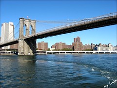
Soon after it was opened, on Memorial Day 1883, a panic on the bridge resulted in a dozen people being trampled to death.

Con artists actually have succeeded in repeatedly selling the Brooklyn Bridge to gullible victims.
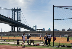
The Brooklyn Banks, located here under the bridge, have been an internationally famous skateboard spot since the 1980s.

1: George Washington moved to this address (sometime called No. 3) on April 23, 1789, when it was the site of a red brick mansion owned by Samuel Osgood, the nation's first postmaster general; on April 30, Washington was sworn in as the first president of the United States. He lived here until February 23, 1790, when the Osgoods wanted their house back. De Witt Clinton was living here in 1817 when he became governor of New York. The historic house was torn down in 1856 when the street was widened; a chair made out of timber salvaged from the ruin is now owned by the New-York Historical Society.

Affixed to the bridge near the corner of Pearl and Dover streets is a plaque marking the approximate spot of the first president's first house.

5: John Hancock lived here in 1786, when he was president of the Continental Congress. William Marcy "Boss" Tweed, future leader of Tammany Hall, was born at this address on April 3, 1823.

7: In 1823, a three-story brick mansion here became the first home in New York City to be lit by gas. The owner, Samuel Leggett, was the president of the New York Gas Light Company.


S <===     WAGNER PLACE     ===> N

Al Smith Houses

Knickerbocker Village by Atlantiquon

NYC Housing Authority project named for a neighborhood kid who grew up to be governor of New York, successfully pushing for improvements in housing, working conditions and child welfare. In 1928, he became the first Roman Catholic to run for president of the United States on a major party ticket, though he lost badly to Herbert Hoover.

The housing project was completed in 1953 and includes 12 buildings, ranging from 15 to 17 stories. It contains 1,931 apartments and houses more than 4,000 people.

27: The modern American flag was born here in 1818, when War of 1812 naval officer Samuel Chester Reid designed the familiar 13-stripe, one-star-for-each-state model. The first prototype, sewn by his wife Mary Reid in the couple's dining room here, flew over the U.S. Capitol on April 12, 1818

Alfred E. Smith Playground

P.S. 126 Jacob Riis Community School

Corner (86 Catherine): A K-8 school serving the Lower East Side and Chinatown. "A rare gem, PS 126 has managed to close the academic gap between children from stable middle-class families and those who struggle with poverty and a raft of social problems," says InsideSchools.org. There's also a middle school in the building, the Manhattan Academy of Technology.


S <===     CATHERINE SLIP/CATHERINE STREET     ===> N

Several roadways change from "Something Street" to "Something Slip" at Cherry Street. This slips used to be little inlets used by boats, now filled in for wheeled traffic.

South:

Tanahey Playground

Named for Martin Tanahey (1874-1930), a Tammany Hall leader and chief lieutenant of Big Tom Foley, namesake of Foley Square.


C
H
E
R
R
Y

S
T
R
E
E
T

North:

Corner: This was the site of the first Brooks Brothers store--opened April 7, 1818, by Henry Sands Brooks, soon joined by his two older brothers. The store began offering the first ready-to-wear suits in 1845, and supplied uniforms to the Union Army in the Civil War-- leading to the store being sacked during the Draft Riots of 1863. The company opened a second location in 1858, and finally moved out of this neighborhood in 1874.

Knickerbocker Village

Block (2 Monroe): A privately built but government-subsidized moderate-income housing project, said to be the first such development in the United States. Developer Fred W. French (builder of Tudor City) put up the 12 13-story buildings that make up the 1,600-unit complex in 1933-34 with the help of the New Deal's Reconstruction Finance Corporation, leveling an entire block (known as Lung Block for its high rate of TB) in the process. The newly opened development went on rent strike in 1934, a landmark in tenant activism.

Julius and Ethel Rosenberg were living here (Building G, apartment 11E) at the time of their arrest on spy charges on July 17, 1950. Other famous residents include Lefty Rugiero (the mobster played by Al Pacino in the film Donnie Brasco), Mark Toby (author of the autobiographical novel The Courtship of Eddie's Father) and opera star Judith Raskin.

The name "Knickerbocker" comes from Diedrich Knickerbocker, the pseudonym of Washington Irving used for his History of New York. It became associated with Dutch New Yorkers and then with New Yorkers in general (as in "New York Knicks").


S <===     MARKET SLIP/MARKET STREET     ===> N

South:

Murry Bergtraum Softball Field

murry bergtraum field by joe holmes, on flickr Bergtraum (1916-74) was a president of the New York City Board of Education.


C
H
E
R
R
Y

S
T

North:

Coleman Playground

Named for U.S. Army Corporal Joseph Francis Coleman, who grew up on Madison Street, fought in France in World War I and died in 1919 of tuberculosis he contracted in the trenches. The Phylis M. Ammirati Ballfield here was named in 1994 for the founder of the park's women's softball league.

The land the park is on was once the graveyard of St. Stephen's Episcopal Church, founded in 1804. After the church closed in 1866, 2,000 bodies were exhumed and transfered to Cypress Hills Cemetery in Brooklyn.

177: Alderman Martin Tanahey, namesake of Tanahey Playground, died of pneumonia at his home here in 1930.

Manhattan Bridge

Manhattan Bridge by NJScott, on Flickr

This was the last of the three suspension bridges crossing the lower East River, opening to traffic in 1909. The chief engineer was Othniel Foster Nichols, assisted by two of the most famous bridge engineers in U.S. history--Leon Moisseiff and Rudolph Modjeski.


S <===     PIKE SLIP/PIKE ST     ===> N

The eastern boundary of the Two Bridges neighborhood.

South:


235: Two Bridges Housing

Corner (80 Rutgers): Two Bridges Senior Apartments, a 10-story building from 1987 with 109 rental units.

C
H
E
R
R
Y

S
T

North:

Rutgers Houses

playground, Rutgers Houses by 2613 say yeah!, on Flickr

Block (61 Pike): An NYC Housing Authority development built in 1965, with five 20-story buildings housing 721 apartment with more than 1,600 residents. It's named for Henry Rutgers (1745-1830), a local landowner and brewer who used to own a large farm on what is now the Lower East Side, including the land this project is built on. He also gave his name to the New Jersey university.


S <===     RUTGERS STREET     ===> N

South:

Corner: Rutgers Park is a small park covering much of the area of the old Rutgers Slip.

251: Two 26-story buildings that share this address, built in 1979, were sold for $171 million in 2008 to the Pembroke Companies.


C
H
E
R
R
Y

S
T

North:

La Guardia Houses

1955, Madison St by CORNERSTONES of NY, on Flickr

300 (block): A NYC Housing Authority complex, built between 1954-57. The five buildings between Rutgers and Clinton streets, each 16 stories, house 610 units. The namesake is Fiorella LaGuardia, mayor of New York City from 1934-45.

272 (corner): LaGuardia Houses Addition, a 16-story apartment building for the elderly, built in 1965.


S <===     JEFFERSON STREET     ===> N

South:

291 (block): A cluster of three-story buildings from 1986.


C
H
E
R
R
Y

S
T

North:

300 (block): More LaGuardia Houses.


S <===     CLINTON STREET     ===> N

South:

Corner: Cherry Clinton Playground


PS/IS 184: Shuang Wen Academy

327 (corner): A public school that offers instruction in both English and Mandarin--the name means "Double Language." Opened in 1998, the school has lately been beset by controversy, including the revelation that it was requiring students to pay $1,000 each to attend a mandatory after-school program.

This used to be PS 137, the John L. Bernstein School, which relocated to East Broadway.

C
H
E
R
R
Y

S
T

North:

318 (block): More La Guardia Houses: Four X-shaped NYC Housing Authority buildings, each 16 stories high, built in 1955. Includes a total of 492 housing units.

The Cherry Street side of this block was the site of Belvedere Hall, a tavern and grounds that were considered to be the first country club in America when it opened in 1793. Only 33 gentlemen were allowed to be members--a suspiciously Masonic number. Jerome Bonaparte, brother of Napoleon, rented the place in the summer and fall of 1804 while hiding out from the British.

330: The childhood home of songwriter Irving Berlin, whose family moved here shortly after they immigrated from Russia in 1893, when Israel "Izzy" Beilin was five. He moved out when he was 14, c. 1902, to make his living singing in bars.


S <===     MONTGOMERY STREET     ===> N

Corner (604 Water): Gouverneur Gardens III, one of a series of 21-story moderate-income co-op buildings from 1963. There was an arson fire in the complex in 1997 that was an attempt to hide evidence of an apartment-selling conspiracy.

The project is named for Gouverneur Street, which in turn is named for Abraham Gouverneur, a 17th century merchant who was an ally of Jacob Leisler, the governor who was hanged for treason. Gouverneur himself was sentenced to death in absentia after fleeing to Boston--but still has a street named after him.

Lillian Wald Playground

After being dedicated to social reformer and promoter of outdoor recreation Lillian Wald in 1937, this space was abandoned for decades before being restored and reopened in 2005.

University Neighborhood High School

Corner (200 Monroe): A public school designed to prepare students for four-year colleges, run in collaboration with New York University. Also includes a middle school.


S <===     GOUVERNEUR STREET     ===> N

Vladeck Houses

Untitled by minusbaby, on Flickr

Block (636-668 Water): An NYC Housing Authority development comprising 20 six-story buildings, mostly with a zigzag shape, built in 1940. They include 1,523 apartments housing some 2,800 people. They're named for Baruch Charney Vladeck, general manager of the Jewish Daily Forward and co-founder of the anti-fascist Jewish Labor Committee, who promoted public housing as a Socialist alderman. He was on the original board of the NYCHA.

In the middle of the complex is Vladeck Park.


S <===     JACKSON STREET     ===> N

South:

Corlears Hook Park

The original shoreline of Manhattan took a right turn near here, a point of land known as Nechtanc by the Lenape and renamed Corlears Hook by the Dutch, after schoolmaster Jacobus van Corlaer, who had a farm here. On February 25, 1643, New Amsterdam's Director-General Willem Kieft ordered his men to kill Munsee Indians camped here, refugees from warfare to the north. Along with another massacre in Pavonia, New Jersey, the same night, some 120 Indians were killed, including many infants and children. During the Battle of Brooklyn, embankments were set up here to impede the British pursuit of the retreating Colonial army.

As early as 1816, the Hook was known as "a resort for the lewd and abandoned of both sexes"; by 1859, the Dictionary of Americanisms was tracing the word "hooker" to "the number of houses of ill-fame frequented by sailors" here. In the 1860s, the waterfront here was the lair of the Hook Gang, river pirates led by men like Terry Le Strange, Suds Merrick and Bum Mahoney. The pirates were crushed by the Steamboat Squad by the end of the 1870s.

The city purchased this land in 1893, turning it into much needed parkland in 1905. The Parks Enforcement Patrol station located here is responsible for park safety south of 42nd Street.

A footbridge across the FDR Drive connects this park to the East River Park.

C
H
E
R
R
Y

S
T
R
E
E
T

North:

Vladeck II Houses

Corner (14 Jackson): An annex to the main Vladeck project, with four six-story buildings housing 238 apartments and more than 400 residents. They were actually completed a month before the "first" Vladeck houses, in October 1940.


Corlears Hook Houses

Corner (453 FDR Drive): AKA the ILGWU Cooperative Village--built as cooperative housing by the International Ladies Garment Workers Union in 1956. Consists of four apartment buildings with (originally, at least) 1,672 apartments. Replaced the Goerck Street tenements, considered at the time to be one of the toughest parts of the Lower East Side.

S <===     FDR DRIVE     ===> N

Cherry Street originally ended at the foot of Grand Stre

East River Park

Robert Moses built this 57-acre park on landfill and former docks in the 1930s, during the construction of the FDR Drive. The section nearest the river had to be closed and reconstructed during the early 21st Century, because decreasing pollution in the East River allowed woodworms to survive to eat the wooden pilings that supported it.
The actual point of Corlaers Hook was located near the east end of the pedestrian bridge that crosses the FDR near the foot of Cherry.

Corlears Hook Amphitheater

Built in 1941 to bring culture to the East River Park. Joseph Papp put on Julius Caesar here in 1956, and the Group of Ancient Drama used to do the Greek classics. Closed in 1973, it became a ruin, it was restored in 2001, and has since hosted concerts by acts like KRS-One, Slick Rick and Willie Colon. It was featured on Flight of the Conchords as part of Murray's rotunda tour.

Lower East Side Ecology Center

A non-profit group based in the park that offers environmental education along with composting and recycling programs. Founded 1987.


What's missing from Cherry Street? Write to Jim Naureckas and tell him about it.

New York Songlines Home.

Sources for the Songlines.

NYSonglines' Facebook Fan Page.

Share